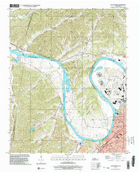
1997 Map of Scottsboro
USGS Topo · Published 2002About this map
Cumberland River meanders through the heart of this landscape, forming the wide Whites Bend and creating a natural boundary for the sprawling State Penitentiary grounds. This area of Davidson County showcases the transition from the steep, hollow-filled terrain of the west to the more developed suburbs of Nashville in the southeast. Along the river's edge, Cheatham Lake provides a backdrop for the Bull Run Recreation Area and the Rock Harbor Marina, reflecting the importance of the waterway for both utility and leisure.
Find a feature on this map
41 named features on this map. Tap any name to fly to it.
Don’t see what you’re looking for? This feature index may not catch every label — zoom into the map to look around manually.
Map Details
Editions of this 1997 Scottsboro Map
This is the sole edition of this map. No revisions or reprints were ever made.
Other maps of this area

1903 · Nashville
USGS Topo · 1:125,000

1930 · White Bluff
USGS Topo · 1:62,500

1931 · Ridgetop
USGS Topo · 1:62,500

1932 · Nashville
USGS Topo · 1:62,500

1933 · White Bluff
USGS Topo · 1:62,500

1935 · Ridgetop
USGS Topo · 1:62,500

1952 · Nashville West
USGS Topo · 1:24,000
1953 · Oak Hill
USGS Topo · 1:24,000

1955 · Whites Creek
USGS Topo · 1:24,000

1955 · Forest Grove
USGS Topo · 1:24,000