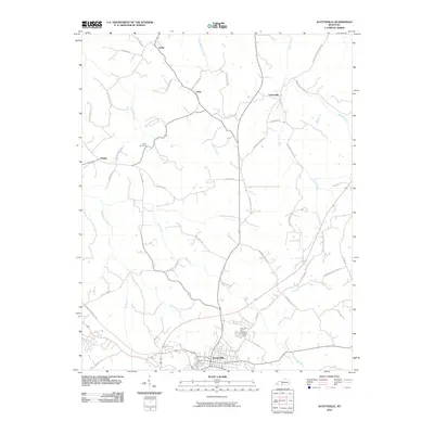
2010 Map of Scottsville
USGS Topo · Published 2010About this map
Scottsville serves as the primary hub in this southern Kentucky landscape, where the town’s grid meets a sprawling network of country roads named for the families and landmarks they connect. The terrain is defined by the winding paths of Bays Fork and West Bays Fork, which drain the rolling agricultural lands surrounding small communities like Gainesville and Halifax. Local history is anchored by sites like Crescent Hill Cemetery and Tabor Cemetery, while the presence of roads such as Jefferson School Rd and Harrison School Rd points to the former locations of rural schoolhouses. These older routes, including Old US 31E Rd and Old Gainesville Rd, trace the evolution of travel through the county, showing how modern infrastructure like the Veterans Memorial Hwy has bypassed earlier settlements like Yesse and Settle.
Find a feature on this map
45 named features on this map. Tap any name to fly to it.
Don’t see what you’re looking for? This feature index may not catch every label — zoom into the map to look around manually.
Map Details
Editions of this 2010 Scottsville Map
This is the sole edition of this map. No revisions or reprints were ever made.
Other maps of this area

1921 · Bowling Green
USGS Topo · 1:62,500

1923 · Bowling Green
USGS Topo · 1:62,500

1926 · Scottsville
USGS Topo · 1:62,500

1928 · Adolphus
USGS Topo · 1:48,000

1931 · Lafayette
USGS Topo · 1:62,500

1931 · Adolphus
USGS Topo · 1:62,500

1942 · Gallatin
USGS Topo · 1:100,000

1954 · Austin
USGS Topo · 1:24,000

1954 · Petroleum
USGS Topo · 1:24,000
1954 · Polkville
USGS Topo · 1:24,000