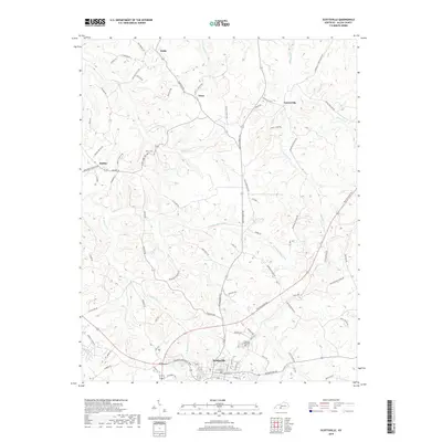
2019 Map of Scottsville
USGS Topo · Published 2019About this map
Scottsville serves as the primary hub in this portion of Allen County, where the landscape is defined by the intricate drainage systems of Bays Fork and Difficult Cr. The town structure is clearly visible, anchored by Crescent Hill Cem at its northern edge. Beyond the city center, the terrain is marked by a network of rural routes such as Smiths Grove Rd and New Glasgow Rd, connecting smaller community centers like Gainesville and Halifax.
Find a feature on this map
77 named features on this map. Tap any name to fly to it.
Don’t see what you’re looking for? This feature index may not catch every label — zoom into the map to look around manually.
Map Details
Editions of this 2019 Scottsville Map
This is the sole edition of this map. No revisions or reprints were ever made.
Other maps of this area

1921 · Bowling Green
USGS Topo · 1:62,500

1923 · Bowling Green
USGS Topo · 1:62,500

1926 · Scottsville
USGS Topo · 1:62,500

1928 · Adolphus
USGS Topo · 1:48,000

1931 · Lafayette
USGS Topo · 1:62,500

1931 · Adolphus
USGS Topo · 1:62,500

1942 · Gallatin
USGS Topo · 1:100,000

1954 · Austin
USGS Topo · 1:24,000

1954 · Petroleum
USGS Topo · 1:24,000
1954 · Polkville
USGS Topo · 1:24,000