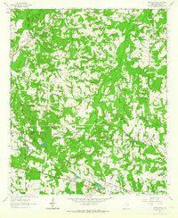
1962 Map of Scottsville
USGS Topo · Published 1964About this map
Harrison Bayou carves a deep path through the piney woods of East Texas in this 1962 record of the area surrounding Scottsville. The landscape is defined by its rural social centers, featuring long-established landmarks like James Chapel, Antioch Ch, and the Kelly Sch. In the eastern portion of the quadrangle, the community of Latex sits near the state line, while infrastructure for the local energy economy is evident through the widespread Pipeline network and the Scottsville Field.
Find a feature on this map
28 named features on this map. Tap any name to fly to it.
Don’t see what you’re looking for? This feature index may not catch every label — zoom into the map to look around manually.
Map Details
Editions of this 1962 Scottsville Map
2 editions found
Other maps of this area

1943 · Waskom
USGS Topo · 1:62,500

1944 · Caddo Lake
USGS Topo · 1:62,500

1945 · Waskom
USGS Topo · 1:62,500

1946 · Caddo Lake
USGS Topo · 1:62,500

1956 · Tyler
USGS Topo · 1:250,000

1958 · Darco
USGS Topo · 1:62,500

1962 · Woodlawn
USGS Topo · 1:24,000
1962 · Potters Point
USGS Topo · 1:24,000
1962 · Karnack
USGS Topo · 1:24,000

1962 · Stricklin Springs
USGS Topo · 1:24,000