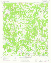
1962 Map of Scottsville
USGS Topo · Published 1978About this map
The Scottsville area of Harrison County, as documented in 1962 and updated in the late 1970s, reveals a rural landscape defined by an extensive network of family and community landmarks. The Scottsville Oil Field and scattered claypits and gravel pits suggest a local economy tied to the land's resources, while the Missouri Pacific and Texas and Pacific railroads provide the primary transit corridors through the wooded terrain. Historical continuity is evident in the density of religious and educational sites, such as Antioch Ch, Antioch Sch, and several family burial grounds like Scott Cem and Motley Cem. Waterways including Harrison Bayou and Haggerty Creek weave through the landscape, punctuated by local landmarks like the Karnack Lookout Tower and the Pumping Station near the southern oil fields.
Find a feature on this map
30 named features on this map. Tap any name to fly to it.
Don’t see what you’re looking for? This feature index may not catch every label — zoom into the map to look around manually.
Map Details
Editions of this 1962 Scottsville Map
2 editions found
Other maps of this area

1943 · Waskom
USGS Topo · 1:62,500

1944 · Caddo Lake
USGS Topo · 1:62,500

1945 · Waskom
USGS Topo · 1:62,500

1946 · Caddo Lake
USGS Topo · 1:62,500

1956 · Tyler
USGS Topo · 1:250,000

1958 · Darco
USGS Topo · 1:62,500

1962 · Woodlawn
USGS Topo · 1:24,000
1962 · Potters Point
USGS Topo · 1:24,000
1962 · Karnack
USGS Topo · 1:24,000

1962 · Stricklin Springs
USGS Topo · 1:24,000