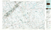
1986 Map of Scranton
USGS Topo · Published 1986About this map
Scranton and Wilkes-Barre anchor this industrial and military landscape during the mid-1980s, a period when the region's coal-mining heritage remained visible through numerous Strip Mine and Gravel Pit sites. The urban corridor following the Lackawanna River is densely packed with boroughs like Dunmore, Old Forge, and Taylor, while higher elevations feature the Tobyhanna Army Depot and sprawling recreation areas like Tobyhanna State Park. Transportation networks are heavily emphasized, showing the Northeast Extension Pennsylvania Turnpike and Interstate 81 threading through the Moosic Mountains. Cultural landmarks including the University of Scranton and Marywood College appear alongside essential infrastructure like the Wilkes-Barre Scranton International Airport. To the east, the terrain transitions into the heavily forested Poconos, marked by Lake Wallenpaupack and the Delaware River boundary between Pennsylvania and New Jersey.
Find a feature on this map
99 named features on this map. Tap any name to fly to it.
Don’t see what you’re looking for? This feature index may not catch every label — zoom into the map to look around manually.
Map Details
Editions of this 1986 Scranton Map
2 editions found
Other maps of this area

1888 · Hackettstown
USGS Topo · 1:62,500

1889 · Scranton
USGS Topo · 1:62,500

1889 · Hazleton
USGS Topo · 1:62,500

1891 · Wilkesbarre
USGS Topo · 1:62,500

1891 · Hazleton
USGS Topo · 1:62,500

1891 · Wallpack
USGS Topo · 1:62,500

1891 · Scranton
USGS Topo · 1:62,500

1891 · Delaware Water Gap
USGS Topo · 1:62,500

1891 · Harveys Lake
USGS Topo · 1:62,500

1892 · Honesdale
USGS Topo · 1:62,500