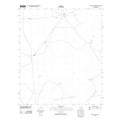
2010 Map of Scratch Ranch
USGS Topo · Published 2010About this map
Scratch Ranch serves as a lone namesake landmark in this arid stretch of West Texas, where the landscape is defined by the vital water infrastructure necessary for ranching. The presence of numerous engineered water catchments, including Red Mill Tank and Twenty Tank, underscores the critical importance of water management in a region drained by seasonal features like South Well Draw and Antelope Gulch. This 2010 survey illustrates the isolation and scale of Hudspeth County holdings, connected by a spare network consisting primarily of FM 1111 and the unpaved Scratch Rd. Historic markers of habitation and land use are preserved through labels such as the El Cuervo Windmill and the various cattle tanks scattered across the high desert terrain.
Find a feature on this map
17 named features on this map. Tap any name to fly to it.
Don’t see what you’re looking for? This feature index may not catch every label — zoom into the map to look around manually.
Map Details
Editions of this 2010 Scratch Ranch Map
This is the sole edition of this map. No revisions or reprints were ever made.
Other maps of this area

1895 · Sierra Blanca
USGS Topo · 1:125,000

1948 · Triple Hill
USGS Topo · 1:62,500

1951 · Red Hills
USGS Topo · 1:62,500

1954 · Van Horn
USGS Topo · 1:250,000

1955 · Black Mountains
USGS Topo · 1:62,500

1958 · Van Horn
USGS Topo · 1:250,000

1973 · Norton Mesa
USGS Topo · 1:24,000
1979 · Black Hills
USGS Topo · 1:24,000
1979 · Gunsight Hills North
USGS Topo · 1:24,000
1984 · Baylor Draw
USGS Topo · 1:24,000