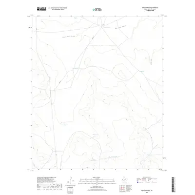
2019 Map of Scratch Ranch
USGS Topo · Published 2019About this map
Scratch Ranch serves as a lonely landmark in this arid portion of Hudspeth County, where the landscape is defined by an extensive network of water management features essential for high-desert ranching. The terrain is carved by ephemeral drainages such as Antelope Gulch, South Well Draw, and Miller Draw, which channel seasonal runoff into a series of named earthen tanks. These livestock watering points, including Red Mill Tank, Twenty Tank, and Cuatrojulio Tank, are the primary evidence of human modification across this sparsely populated territory. Remote access is provided by FM 1111 and the unpaved Scratch Rd, which navigate the elevation changes between the draws and the rising slopes of the surrounding hills, such as those near Black Mountain Tank.
Find a feature on this map
16 named features on this map. Tap any name to fly to it.
Don’t see what you’re looking for? This feature index may not catch every label — zoom into the map to look around manually.
Map Details
Editions of this 2019 Scratch Ranch Map
This is the sole edition of this map. No revisions or reprints were ever made.
Other maps of this area

1895 · Sierra Blanca
USGS Topo · 1:125,000

1948 · Triple Hill
USGS Topo · 1:62,500

1951 · Red Hills
USGS Topo · 1:62,500

1954 · Van Horn
USGS Topo · 1:250,000

1955 · Black Mountains
USGS Topo · 1:62,500

1958 · Van Horn
USGS Topo · 1:250,000

1973 · Norton Mesa
USGS Topo · 1:24,000
1979 · Black Hills
USGS Topo · 1:24,000
1979 · Gunsight Hills North
USGS Topo · 1:24,000
1984 · Baylor Draw
USGS Topo · 1:24,000