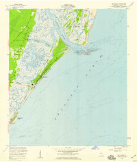
1955 Map of Sea Island
USGS Topo · Published 1959About this map
Saint Simons Island and its smaller neighbor Sea Island are depicted during the mid-1950s, a period showing both early resort development and established local settlements. The geography is defined by a dense network of tidal waterways including the Hampton River and Village Creek, which weave through the marshlands and separate the main islands from the shifting sands of the Atlantic Ocean coast.
Find a feature on this map
32 named features on this map. Tap any name to fly to it.
Don’t see what you’re looking for? This feature index may not catch every label — zoom into the map to look around manually.
Map Details
Editions of this 1955 Sea Island Map
This is the sole edition of this map. No revisions or reprints were ever made.
Other maps of this area

1920 · Cabretta Island
USGS Topo · 1:62,500

1921 · Darien
USGS Topo · 1:62,500

1944 · Cabretta Island
USGS Topo · 1:62,500

1945 · Brunswick
USGS Topo · 1:62,500

1946 · Brunswick
USGS Topo · 1:250,000

1948 · Brunswick
USGS Topo · 1:250,000

1954 · Altamaha Sound
USGS Topo · 1:24,000
1956 · Brunswick East
USGS Topo · 1:24,000
1956 · Darien
USGS Topo · 1:24,000

1956 · Brunswick
USGS Topo · 1:250,000