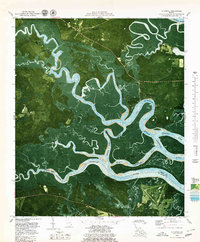
1979 Map of Seabrook
USGS Topo · Published 1979About this map
The North Newport River and South Newport River carve a complex path through the tidal marshes of Liberty and McIntosh counties in this late-1970s orthophotomap. This coastal landscape is defined by its winding waterways, including the Payne River and Timmons River, which isolate high ground like Colonels Island and Harris Neck. The map provides an intricate look at the marsh-to-upland transition, showing the distribution of wooded hammocks such as Cattle Hammock and expansive open areas like Olmstead Pasture.
Find a feature on this map
32 named features on this map. Tap any name to fly to it.
Don’t see what you’re looking for? This feature index may not catch every label — zoom into the map to look around manually.
Map Details
Editions of this 1979 Seabrook Map
2 editions found
Other maps of this area

1920 · Sapelo River
USGS Topo · 1:62,500

1920 · Limerick
USGS Topo · 1:62,500

1928 · St Catherines Island
USGS Topo · 1:62,500

1943 · St Catherines Island
USGS Topo · 1:62,500

1943 · Sapelo River
USGS Topo · 1:62,500

1944 · Limerick
USGS Topo · 1:62,500

1944 · Ossabaw Island
USGS Topo · 1:62,500

1945 · St. Catherine's Island
USGS Topo · 1:62,500

1945 · Ossabaw Island
USGS Topo · 1:62,500

1945 · Sapelo River
USGS Topo · 1:62,500