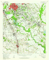
1959 Map of Seagoville
USGS Topo · Published 1962About this map
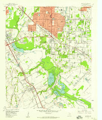
The Trinity River corridor dominates this southeast Dallas landscape, defining the boundaries and character of communities like Hutchins, Wilmer, and Seagoville. The river's floodplain is a complex network of wetlands and seasonal water bodies, including Parsons Slough and the expansive Bois D'Arc Island, which sits between the main channel and the East Fork Trinity River. This area is heavily influenced by early industrial and institutional land use, evidenced by the Federal Correctional Institution near Seagoville and the Hutchins Boys Industrial Sch.
Find a feature on this map
90 named features on this map. Tap any name to fly to it.
Don’t see what you’re looking for? This feature index may not catch every label — zoom into the map to look around manually.
Map Details
Editions of this 1959 Seagoville Map
This is the sole edition of this map. No revisions or reprints were ever made.
Other maps of this area

1891 · Dallas
USGS Topo · 1:125,000

1893 · Dallas
USGS Topo · 1:125,000

1919 · Royse City
USGS Topo · 1:62,500

1931 · Carrollton
USGS Topo · 1:62,500

1954 · Dallas
USGS Topo · 1:250,000
1956 · Ennis
USGS Topo · 1:62,500
1956 · Kaufman
USGS Topo · 1:62,500
1957 · White Rock Lake
USGS Topo · 1:24,000

1958 · Dallas
USGS Topo · 1:250,000
1958 · Hutchins
USGS Topo · 1:24,000