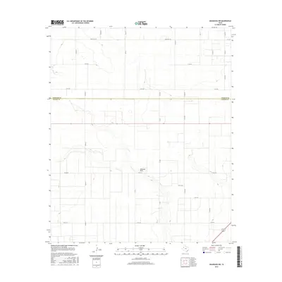
2016 Map of Seagraves NW
USGS Topo · Published 2016About this map
McKenzie Draw carves a subtle path through the High Plains landscape of the Texas Panhandle, defining the drainage patterns across this section of the Llano Estacado. The terrain is characterized by the expansive, relatively level surface typical of this region, interrupted only by the gentle depressions of ephemeral watercourses. A dense grid of county roads, such as Co Rd 222 and Co Rd 370, indicates the systematic division of the land for agricultural use and ranching. The map highlights the administrative boundary between Yoakum Co and Gaines Co, illustrating how political lines were laid out across the open prairie. Major thoroughfares like Ranch Rd 1939 and Fm 1939 provide the primary connection for the scattered rural homesteads and industrial sites that populate this late-contemporary West Texas environment.
Find a feature on this map
27 named features on this map. Tap any name to fly to it.
Don’t see what you’re looking for? This feature index may not catch every label — zoom into the map to look around manually.
Map Details
Editions of this 2016 Seagraves NW Map
This is the sole edition of this map. No revisions or reprints were ever made.
Other maps of this area

1954 · Hobbs
USGS Topo · 1:250,000

1954 · Brownfield
USGS Topo · 1:250,000

1958 · Brownfield
USGS Topo · 1:250,000

1958 · Hobbs
USGS Topo · 1:250,000

1962 · Brownfield
USGS Topo · 1:250,000

1970 · Seagraves SW
USGS Topo · 1:24,000

1970 · Seagraves SE
USGS Topo · 1:24,000

1970 · Seagraves
USGS Topo · 1:24,000
1970 · Tokio SE
USGS Topo · 1:24,000

1970 · Pleasant Hill
USGS Topo · 1:24,000