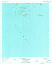
1955 Map of Seahorse Key
USGS Topo · Published 1976About this map
Cedar Keys National Wildlife Refuge encompasses a scattered archipelago off the Florida coast, protecting a series of biologically significant islands during the mid-1950s. The topographic detail highlights the maritime history of the region, specifically marking an Lighthouse (Abandoned) on Seahorse Key and the Atsena Otie Cem on the island once known as the original site of the Cedar Key settlement. The surrounding waters of the Gulf of Mexico are charted with significant depth contours and navigational markers, including Deadmans Channel and the Main Ship Channel. These waterways define the approach to the islands, while natural features like Seahorse Reef and the West Bank suggest the challenging coastal environment that necessitated the early aids to navigation found on this map.
Find a feature on this map
17 named features on this map. Tap any name to fly to it.
Don’t see what you’re looking for? This feature index may not catch every label — zoom into the map to look around manually.
Map Details
Editions of this 1955 Seahorse Key Map
4 editions found
Other maps of this area

1954 · Gainesville
USGS Topo · 1:250,000

1955 · Seahorse Key
USGS Topo · 1:24,000

1955 · Cedar Key
USGS Topo · 1:24,000

1955 · Sumner
USGS Topo · 1:24,000

1955 · Plant City
USGS Topo · 1:250,000

1958 · Plant City
USGS Topo · 1:250,000

1958 · Gainesville
USGS Topo · 1:250,000

1959 · Plant City
USGS Topo · 1:250,000

1959 · Gainesville
USGS Topo · 1:250,000

1964 · Plant City
USGS Topo · 1:250,000