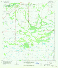
1958 Map of Sears
USGS Topo · Published 1969About this map
The Caloosahatchee River defines the northern reaches of this Florida landscape, where early water management and land development efforts are clearly visible. Near the northern edge, the City Boundary of La Belle extends toward the La Belle Airport, marking a period of municipal growth and aviation expansion. The terrain is characterized by numerous Marl Pits and several artesian sources, including a Flowing Well and Flowing Wells, which highlight the region's unique hydrology.
Find a feature on this map
9 named features on this map. Tap any name to fly to it.
Don’t see what you’re looking for? This feature index may not catch every label — zoom into the map to look around manually.
Map Details
Editions of this 1958 Sears Map
3 editions found
Other maps of this area

1956 · West Palm Beach
USGS Topo · 1:250,000

1957 · West Palm Beach
USGS Topo · 1:250,000

1957 · Telegraph Swamp SE
USGS Topo · 1:24,000

1958 · West Palm Beach
USGS Topo · 1:250,000

1958 · Felda SE
USGS Topo · 1:24,000

1958 · Goodno
USGS Topo · 1:24,000

1958 · Felda
USGS Topo · 1:24,000

1958 · Felda NE
USGS Topo · 1:24,000

1958 · Alva
USGS Topo · 1:24,000

1958 · Sears
USGS Topo · 1:24,000