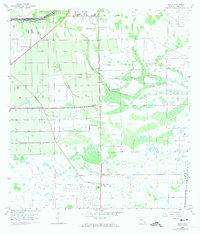
1958 Map of Sears
USGS Topo · Published 1974About this map
The Caloosahatchee River anchors the northern edge of this Hendry County landscape, where the La Belle City Boundary meets a complex network of agricultural drainage and irrigation. Evidence of the region’s groundwater dependence is scattered throughout the interior, marked by numerous Flowing Wells and Flowing Well labels that supported local farming operations. This 1958 topographic study, which includes aerial photo revisions from 1973, captures the rural infrastructure essential to South Florida’s development.
Find a feature on this map
9 named features on this map. Tap any name to fly to it.
Don’t see what you’re looking for? This feature index may not catch every label — zoom into the map to look around manually.
Map Details
Editions of this 1958 Sears Map
3 editions found
Other maps of this area

1956 · West Palm Beach
USGS Topo · 1:250,000

1957 · West Palm Beach
USGS Topo · 1:250,000

1957 · Telegraph Swamp SE
USGS Topo · 1:24,000

1958 · West Palm Beach
USGS Topo · 1:250,000

1958 · Felda SE
USGS Topo · 1:24,000

1958 · Goodno
USGS Topo · 1:24,000

1958 · Felda
USGS Topo · 1:24,000

1958 · Felda NE
USGS Topo · 1:24,000

1958 · Alva
USGS Topo · 1:24,000

1958 · Sears
USGS Topo · 1:24,000