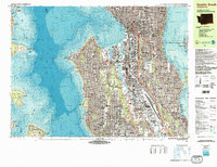
1983 Map of Seattle South
USGS Topo · Published 1983About this map
The Seattle waterfront and industrial corridor along the Duwamish River anchor this 1983 topographic-bathymetric study. The map captures the complex interaction between the deep waters of Puget Sound and the built environment of the city, dominated by the Duwamish Waterway and the expansive rail yards of the Burlington Northern. Prominent landmarks such as the Kingdome and King Co Boeing Field International Airport define the urban landscape, while the presence of the Coast Guard Res at Alki Point underscores the maritime strategic importance of the Elliott Bay entrance.
Find a feature on this map
113 named features on this map. Tap any name to fly to it.
Don’t see what you’re looking for? This feature index may not catch every label — zoom into the map to look around manually.
Map Details
Editions of this 1983 Seattle South Map
Other maps of this area

1894 · Seattle
USGS Topo · 1:62,500

1895 · Snohomish
USGS Topo · 1:125,000

1897 · Tacoma
USGS Topo · 1:125,000

1897 · Seattle
USGS Topo · 1:125,000

1900 · Tacoma
USGS Topo · 1:125,000

1908 · Seattle
USGS Topo · 1:62,500

1909 · Seattle Special
USGS Topo · 1:62,500

1937 · Port Orchard
USGS Topo · 1:62,500

1942 · Gig Harbor
USGS Topo · 1:62,500

1943 · Gig Harbor
USGS Topo · 1:62,500