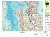
1983 Map of Seattle South
USGS Topo · Published 1983About this map
Industrial corridors and waterfront development define this mid-1980s look at Seattle and its surrounding waterways. The Duwamish Waterway serves as the spine for heavy shipping and transit, flanked by the Burlington Northern and Union Pacific railroads. On the downtown waterfront, the Alaskan Way Viaduct and the Space Needle stand as modern landmarks of the era, while the massive Kingdome anchors the rail yards near King Street Station.
Find a feature on this map
184 named features on this map. Tap any name to fly to it.
Don’t see what you’re looking for? This feature index may not catch every label — zoom into the map to look around manually.
Map Details
Editions of this 1983 Seattle South Map
Other maps of this area

1894 · Seattle
USGS Topo · 1:62,500

1895 · Snohomish
USGS Topo · 1:125,000

1897 · Tacoma
USGS Topo · 1:125,000

1897 · Seattle
USGS Topo · 1:125,000

1900 · Tacoma
USGS Topo · 1:125,000

1908 · Seattle
USGS Topo · 1:62,500

1909 · Seattle Special
USGS Topo · 1:62,500

1937 · Port Orchard
USGS Topo · 1:62,500

1942 · Gig Harbor
USGS Topo · 1:62,500

1943 · Gig Harbor
USGS Topo · 1:62,500