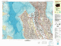
1983 Map of Seattle South
USGS Topo · Published 1983About this map
Elliott Bay and the industrial waterfront of Seattle dominate this 1980s topographic-bathymetric study, revealing a city defined by its relationship to the water. The urban core is marked by landmarks like the Space Needle, the Kingdome, and the bustling activity at Colman Dock and Pier 70. Beyond the central business district, the map traces the residential and commercial development across Beacon Hill, Capitol Hill, and the neighborhoods of West Seattle. The industrial importance of the Duwamish River is clear, with its engineered Duwamish Waterway and Harbor Island serving as a hub for maritime commerce. Transport networks are in a state of maturity, featuring Interstate 5 and the Alaskan Way Viaduct alongside the rail lines of the Burlington Northern and Union Pacific. Across the Puget Sound, the map details the eastern shores of Bainbridge Island and Vashon Island, providing a comprehensive look at the maritime geography of the region.
Find a feature on this map
121 named features on this map. Tap any name to fly to it.
Don’t see what you’re looking for? This feature index may not catch every label — zoom into the map to look around manually.
Map Details
Editions of this 1983 Seattle South Map
Other maps of this area

1894 · Seattle
USGS Topo · 1:62,500

1895 · Snohomish
USGS Topo · 1:125,000

1897 · Tacoma
USGS Topo · 1:125,000

1897 · Seattle
USGS Topo · 1:125,000

1900 · Tacoma
USGS Topo · 1:125,000

1908 · Seattle
USGS Topo · 1:62,500

1909 · Seattle Special
USGS Topo · 1:62,500

1937 · Port Orchard
USGS Topo · 1:62,500

1942 · Gig Harbor
USGS Topo · 1:62,500

1943 · Gig Harbor
USGS Topo · 1:62,500