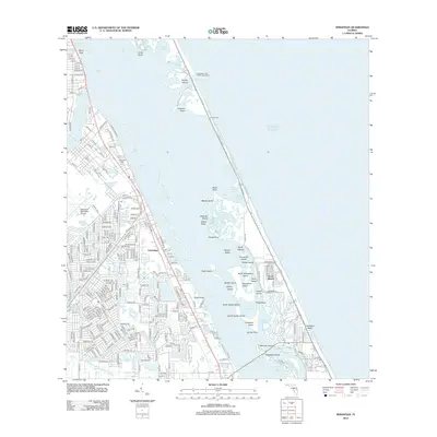
2012 Map of Sebastian
USGS Topo · Published 2012About this map
The Indian River separates the mainland from the barrier islands in this coastal survey, where the Saint Sebastian River joins the larger estuary. The town of Sebastian is the primary settlement, featuring a grid of residential streets and the Sebastian Municipal Airport. Along the waterway, smaller communities like Cummings and the waterfront developments at North Beach and Wabasso Beach trace the shoreline. The geography is defined by a dense network of islands and tidal features, including Orchid Island and the protected lands of Pelican Island.
Find a feature on this map
256 named features on this map. Tap any name to fly to it.
Don’t see what you’re looking for? This feature index may not catch every label — zoom into the map to look around manually.
Map Details
Editions of this 2012 Sebastian Map
This is the sole edition of this map. No revisions or reprints were ever made.
Other maps of this area

1948 · Riomar
USGS Topo · 1:24,000

1949 · Fellsmere
USGS Topo · 1:24,000

1949 · Sebastian NW
USGS Topo · 1:24,000

1949 · Vero Beach
USGS Topo · 1:24,000

1949 · Sebastian
USGS Topo · 1:24,000

1949 · Grant
USGS Topo · 1:24,000

1950 · Riomar
USGS Topo · 1:24,000

1950 · Vero Beach
USGS Topo · 1:24,000

1951 · Sebastian NW
USGS Topo · 1:24,000

1951 · Fellsmere
USGS Topo · 1:24,000