
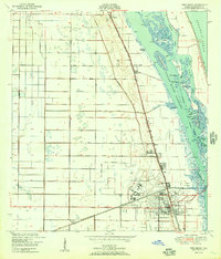
1950 Map of Vero Beach
USGS Topo · Published 1950About this map
Vero Beach and its surrounding citrus-growing landscape are detailed here in a 1950 survey, capturing the region's mid-century aviation and maritime character. The Vero Beach Municipal Airport and adjacent Indian River Hospital occupy the western edge of town, while the Florida East Coast railway runs parallel to the coastline, connecting the coastal communities of Wabasso, Winter Beach, and Gifford. To the east, the complex geography of the Indian River Narrows reveals a network of islands and waterways, including Johns Island and the curiously named Hole in the Wall Island. The landscape between the Atlantic Ocean and the mainland is defined by drainage features like the North Canal and Main Canal, reflecting the intensive water management necessary for local agriculture and development in this era of Florida's Atlantic coast expansion.
Find a feature on this map
40 named features on this map. Tap any name to fly to it.
Don’t see what you’re looking for? This feature index may not catch every label — zoom into the map to look around manually.
Map Details
Editions of this 1950 Vero Beach Map
2 editions found
Other maps of this area

1948 · Riomar
USGS Topo · 1:24,000

1948 · Indrio
USGS Topo · 1:24,000

1949 · Fellsmere
USGS Topo · 1:24,000

1949 · Vero Beach
USGS Topo · 1:24,000

1949 · Sebastian
USGS Topo · 1:24,000

1949 · Oslo
USGS Topo · 1:24,000

1950 · Riomar
USGS Topo · 1:24,000

1950 · Oslo
USGS Topo · 1:24,000

1950 · Indrio
USGS Topo · 1:24,000

1951 · Fellsmere
USGS Topo · 1:24,000