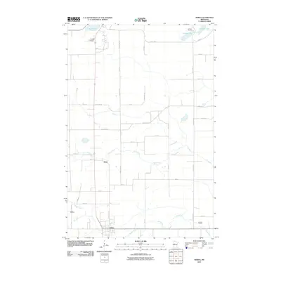
2010 Map of Sebeka
USGS Topo · Published 2010About this map
The Redeye River flows through the southern portion of this landscape, anchoring the settlement of Sebeka. This region of Wadena County is defined by its water systems and rural road grid, featuring a network of tributaries including Kitten Creek and the Cat River. Local history is preserved through several family and community burial grounds, such as Jim Cook Cemetery near Jim Cook Lake and Mantyla Cemetery further south. To the north, Spirit Lake and the Menahga Campground suggest the area's role as a destination for outdoor recreation. The map meticulously documents the 2010 road system, from County Hwy-13 to various numbered township roads, providing a clear view of land divisions and property access points during the early 21st century.
Find a feature on this map
38 named features on this map. Tap any name to fly to it.
Don’t see what you’re looking for? This feature index may not catch every label — zoom into the map to look around manually.
Map Details
Editions of this 2010 Sebeka Map
This is the sole edition of this map. No revisions or reprints were ever made.
Other maps of this area

1953 · Brainerd
USGS Topo · 1:250,000

1957 · Brainerd
USGS Topo · 1:250,000

1958 · Brainerd
USGS Topo · 1:250,000

1965 · Brainerd
USGS Topo · 1:250,000

1969 · Sebeka SW
USGS Topo · 1:24,000

1969 · Menahga
USGS Topo · 1:24,000

1969 · Park Rapids SW
USGS Topo · 1:24,000

1969 · Sebeka
USGS Topo · 1:24,000

1969 · Sebeka NW
USGS Topo · 1:24,000
1969 · Blue Grass
USGS Topo · 1:24,000