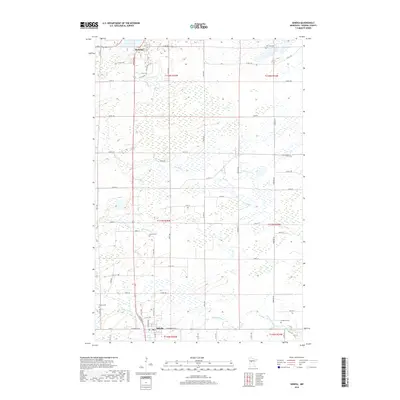
2019 Map of Sebeka
USGS Topo · Published 2019About this map
The transition from the lake country of Menahga to the river valleys of the south is clearly defined on this recent survey. To the north, Spirit Lake serves as a local anchor for the community, while the southern portion of the quadrangle is defined by the winding course of the Redeye River and its tributaries, including Cat River and Kitten Cr. This landscape is marked by a legacy of rural life and early industry, indicated by the corridor along Old Sawmill Rd. The map provides significant genealogical value through its precise documentation of local burial grounds, including the Jim Cook Cem, Mantyla Cem, and the Sebeka Cem located just outside the town of Sebeka. The grid of county roads, such as Co Rd 13 and Co Rd 143, connects these small settlements across the township boundaries of Wadena County.
Find a feature on this map
45 named features on this map. Tap any name to fly to it.
Don’t see what you’re looking for? This feature index may not catch every label — zoom into the map to look around manually.
Map Details
Editions of this 2019 Sebeka Map
This is the sole edition of this map. No revisions or reprints were ever made.
Other maps of this area

1953 · Brainerd
USGS Topo · 1:250,000

1957 · Brainerd
USGS Topo · 1:250,000

1958 · Brainerd
USGS Topo · 1:250,000

1965 · Brainerd
USGS Topo · 1:250,000

1969 · Sebeka SW
USGS Topo · 1:24,000

1969 · Menahga
USGS Topo · 1:24,000

1969 · Park Rapids SW
USGS Topo · 1:24,000

1969 · Sebeka
USGS Topo · 1:24,000

1969 · Sebeka NW
USGS Topo · 1:24,000
1969 · Blue Grass
USGS Topo · 1:24,000