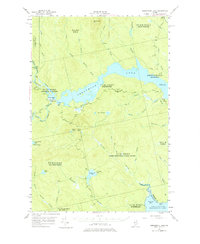
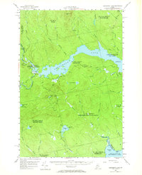
1954 Map of Seboomook Lake
USGS Topo · Published 1977About this map
Pittston Farm stands as a focal point in this 1954 landscape, situated at the confluence of the Penobscot River and its branches just west of Seboomook Lake. The map reveals a remote timber and water-management landscape defined by the regulated waters of the North Branch and South Branch of the Penobscot, which flow into the reservoir near Canada Falls Dam. This era of the North Woods is characterized by large township grants such as Soldier Town and the West Middlesex Canal Grant, reflecting the historic land-use patterns of Maine's interior. In the southeast, the terrain transitions toward the vast waters of Moosehead Lake at Socatean Bay. The network of private roads and numerous brooks like Elm Stream and Socatean Stream illustrate a region shaped by the logging industry and seasonal water control.
Find a feature on this map
50 named features on this map. Tap any name to fly to it.
Don’t see what you’re looking for? This feature index may not catch every label — zoom into the map to look around manually.
Map Details
Editions of this 1954 Seboomook Lake Map
6 editions found

Other maps of this area

1920 · Moosehead Lake
USGS Topo · 1:62,500

1921 · Brassua Lake
USGS Topo · 1:62,500

1922 · Moosehead Lake
USGS Topo · 1:62,500

1922 · Long Pond
USGS Topo · 1:62,500

1923 · Brassua Lake
USGS Topo · 1:62,500

1924 · Long Pond
USGS Topo · 1:62,500

1930 · Moosehead Lake
USGS Topo · 1:62,500

1944 · Brassua Lake
USGS Topo · 1:62,500

1944 · Moosehead Lake
USGS Topo · 1:62,500

1944 · Long Pond
USGS Topo · 1:62,500
Featured Places
- Tomhegan Township, ME
- Elm Stream Township, ME
- West Middlesex Canal Grant Township, ME
- Seboomook Township, ME
- Comstock Township, ME