
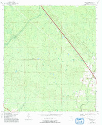
1954 Map of Secotan
USGS Topo · Published 1955About this map
The settlement of Secotan stands at the heart of this Taylor County landscape, defined by a sparse network of water and rail as it appeared in the early 1950s. The Atlantic Coast Line railroad cuts a sharp diagonal across the terrain, serving as a primary corridor through the low-lying wet hammocks. Near the tracks, the Secotan Lookout Tower provided a vital vantage point for fire surveillance over the surrounding timberlands. The Econfina River and Rocky Creek thread through the marshes and hammocks, illustrating the drainage patterns that shaped local land use and transportation during this era. This 1954 topography, compiled in part from 1951 aerial photography, captures the area before modern development altered the rural character of this North Florida interior.
Find a feature on this map
6 named features on this map. Tap any name to fly to it.
Don’t see what you’re looking for? This feature index may not catch every label — zoom into the map to look around manually.
Map Details
Editions of this 1954 Secotan Map
3 editions found

Other maps of this area

1952 · Secotan
USGS Topo · 1:24,000

1954 · Johnson Hammock
USGS Topo · 1:24,000

1954 · Boyd
USGS Topo · 1:24,000

1954 · Hampton Springs
USGS Topo · 1:24,000

1954 · Valdosta
USGS Topo · 1:250,000

1955 · Perry
USGS Topo · 1:24,000

1955 · Shady Grove
USGS Topo · 1:24,000

1955 · Lamont SE
USGS Topo · 1:24,000

1955 · Greenville SE
USGS Topo · 1:24,000

1955 · Manlin Hammock
USGS Topo · 1:24,000