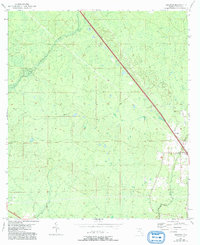
1954 Map of Secotan
USGS Topo · Published 1993About this map
The Econfina River winds through this coastal Florida landscape, defining a terrain dominated by wetlands and low-lying drainages. Mapped by the Geological Survey during the 1950s with later updates, the area reflects the quiet character of the Big Bend region. The small settlement of Secotan serves as the primary focal point, situated near the southeastern edge of the sheet where the Rocky Creek basin begins to transition toward the Gulf. A significant landmark for forest management and navigation is the Secotan Lookout Tower, which provides a vertical vantage point over the dense timber and marshlands that characterize this portion of Taylor County. The map captures a moment when the regional economy relied heavily on these natural watercourses and the surrounding forest resources.
Find a feature on this map
5 named features on this map. Tap any name to fly to it.
Don’t see what you’re looking for? This feature index may not catch every label — zoom into the map to look around manually.
Map Details
Editions of this 1954 Secotan Map
3 editions found

Other maps of this area

1952 · Secotan
USGS Topo · 1:24,000

1954 · Johnson Hammock
USGS Topo · 1:24,000

1954 · Boyd
USGS Topo · 1:24,000

1954 · Hampton Springs
USGS Topo · 1:24,000

1954 · Secotan
USGS Topo · 1:24,000

1954 · Valdosta
USGS Topo · 1:250,000

1955 · Perry
USGS Topo · 1:24,000

1955 · Shady Grove
USGS Topo · 1:24,000

1955 · Lamont SE
USGS Topo · 1:24,000

1955 · Greenville SE
USGS Topo · 1:24,000