
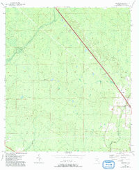
1954 Map of Secotan
USGS Topo · Published 1972About this map
Atlantic Coast Line tracks dominate the northern reaches of Taylor County, carving a straight diagonal path through a landscape defined by wetlands and dense timber. The small settlement of Secotan serves as a focal point along the rail corridor, supported by the Secotan Lookout Tower, which provided a critical vantage point for forest management during the mid-century. Drainage is defined by the winding course of the Econfina River in the northwest and Rocky Creek in the southeast, both of which traverse a topography marked by numerous small sinks and depressions. This 1950s survey captures the region's character as a working forest and transport artery, just as aerial photography began to refine the mapping of Florida’s intricate marshlands and timber stands.
Find a feature on this map
6 named features on this map. Tap any name to fly to it.
Don’t see what you’re looking for? This feature index may not catch every label — zoom into the map to look around manually.
Map Details
Editions of this 1954 Secotan Map
3 editions found
Other maps of this area

1952 · Secotan
USGS Topo · 1:24,000

1954 · Johnson Hammock
USGS Topo · 1:24,000

1954 · Boyd
USGS Topo · 1:24,000

1954 · Hampton Springs
USGS Topo · 1:24,000

1954 · Secotan
USGS Topo · 1:24,000

1954 · Valdosta
USGS Topo · 1:250,000

1955 · Perry
USGS Topo · 1:24,000

1955 · Shady Grove
USGS Topo · 1:24,000

1955 · Lamont SE
USGS Topo · 1:24,000

1955 · Greenville SE
USGS Topo · 1:24,000