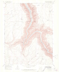
1964 Map of Secret Canyon
USGS Topo · Published 1968About this map
The Dolores River carves a deep path through the canyonlands of Dolores County, defining the rugged geography within the San Juan National Forest. The landscape is dominated by steep-walled canyons and prominent overlooks like Mountain Sheep Point and Glade Point, where an Indefinite Boundary traces the rim. Water management in this arid environment is evident through several small impoundments and vital sources, including Wild Horse Reservoir, Baird Reservoir, and Big Water Spring.
Find a feature on this map
29 named features on this map. Tap any name to fly to it.
Don’t see what you’re looking for? This feature index may not catch every label — zoom into the map to look around manually.
Map Details
Editions of this 1964 Secret Canyon Map
2 editions found
Other maps of this area

1949 · Egnar
USGS Topo · 1:24,000

1949 · Joe Davis Hill
USGS Topo · 1:24,000

1950 · Joe Davis Hill
USGS Topo · 1:24,000

1950 · Egnar
USGS Topo · 1:24,000

1956 · Cortez
USGS Topo · 1:250,000

1957 · Cedar 3 NW
USGS Topo · 1:24,000

1958 · Cortez
USGS Topo · 1:250,000

1959 · Cortez
USGS Topo · 1:250,000

1962 · Cortez
USGS Topo · 1:250,000
1964 · Dawson Draw
USGS Topo · 1:24,000