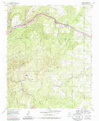
1954 Map of Sedillo
USGS Topo · Published 1986About this map
Sedillo and the surrounding mountain settlements of eastern Bernalillo County are captured here during a period of transition in the mid-1950s. The landscape is defined by the steep drainages of the Manzanita Mountains, where Tijeras Canyon serves as a primary corridor through the Cibola National Forest. While small communities like Zamora and Los Pinos dot the northern canyons, the southern portion of the map reveals specialized rural operations such as the Riedmont Fur Farm and the remote settlement at Juan Tomas. A long-established telephone line cuts across the center of the sheet, tracing the terrain between Primera Agua Canyon and Tablazon Canyon. The mapping also highlights the complex network of mountain drainages, including Sabino Canyon and Cedro Canyon, which converge near the prominence of Cedro Peak.
Find a feature on this map
22 named features on this map. Tap any name to fly to it.
Don’t see what you’re looking for? This feature index may not catch every label — zoom into the map to look around manually.
Map Details
Editions of this 1954 Sedillo Map
4 editions found
Other maps of this area

1892 · San Pedro
USGS Topo · 1:125,000

1917 · Estancia
USGS Topo · 1:125,000

1954 · Sandia Crest
USGS Topo · 1:24,000

1954 · Chilili
USGS Topo · 1:24,000

1954 · Sandia Park
USGS Topo · 1:24,000

1954 · San Pedro
USGS Topo · 1:24,000

1954 · Mount Washington
USGS Topo · 1:24,000
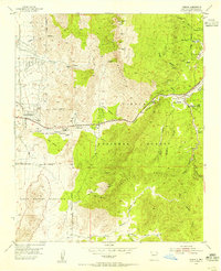
1954 · Tijeras
USGS Topo · 1:24,000

1954 · Sedillo
USGS Topo · 1:24,000

1954 · Escabosa
USGS Topo · 1:24,000