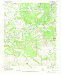
1969 Map of Sedona
USGS Topo · Published 1971About this map
Oak Creek carves a central path through this late-1960s landscape, serving as the primary corridor for both natural drainage and human activity. The settlement of Sedona appears at a transitional stage, centered near the junction of Schnebly Hill Road and showing the development of Grasshopper Flat and the Trailer Park to the west. While the town infrastructure includes the Sedona Sch, Sedona Memorial Park, and the striking Chapel of the Holy Cross, the surrounding terrain remains dominated by the iconic red rock formations of the Coconino National Forest. Landmarks like Cathedral Rock, Bell Rock, and Courthouse Butte stand as massive geological sentinels, while the expansive House Mountain area to the south is marked by numerous stock tanks such as John Lee Tank and Wildhorse Tank, suggesting a continuing legacy of ranching and water management in the high desert.
Find a feature on this map
62 named features on this map. Tap any name to fly to it.
Don’t see what you’re looking for? This feature index may not catch every label — zoom into the map to look around manually.
Map Details
Editions of this 1969 Sedona Map
2 editions found
Other maps of this area

1887 · Verde
USGS Topo · 1:250,000

1892 · Verde
USGS Topo · 1:250,000

1923 · Camp Verde
USGS Topo · 1:125,000

1932 · Camp Verde
USGS Topo · 1:125,000

1936 · Camp Verde
USGS Topo · 1:125,000

1954 · Holbrook
USGS Topo · 1:250,000

1957 · Holbrook
USGS Topo · 1:250,000

1958 · Holbrook
USGS Topo · 1:250,000

1960 · Holbrook
USGS Topo · 1:250,000
1965 · Munds Mountain
USGS Topo · 1:24,000