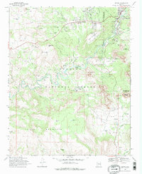
1969 Map of Sedona
USGS Topo · Published 1972About this map
Sedona is shown during a period of significant mid-century growth, bordered by the expansive Coconino National Forest. The map details a landscape where residential expansion at Grasshopper Flat and developments like the Sedona Memorial Park meet the dramatic geological formations of the high desert. Notable structures include the iconic Chapel of the Holy Cross and the Verde Valley Sch to the south.
Find a feature on this map
57 named features on this map. Tap any name to fly to it.
Don’t see what you’re looking for? This feature index may not catch every label — zoom into the map to look around manually.
Map Details
Editions of this 1969 Sedona Map
2 editions found
Other maps of this area

1887 · Verde
USGS Topo · 1:250,000

1892 · Verde
USGS Topo · 1:250,000

1923 · Camp Verde
USGS Topo · 1:125,000

1932 · Camp Verde
USGS Topo · 1:125,000

1936 · Camp Verde
USGS Topo · 1:125,000

1954 · Holbrook
USGS Topo · 1:250,000

1957 · Holbrook
USGS Topo · 1:250,000

1958 · Holbrook
USGS Topo · 1:250,000

1960 · Holbrook
USGS Topo · 1:250,000
1965 · Munds Mountain
USGS Topo · 1:24,000