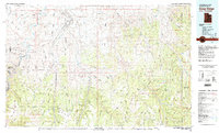
1981 Map of Seep Ridge
USGS Topo · Published 1982About this map
The Uintah and Ouray Indian Reservation dominates this 1980s landscape, spanning a high-desert region defined by deep drainage systems and early energy exploration. The Green River carves through the west, creating the dramatic depths of Desolation Canyon and Gray Canyon. To the east, the White River flows toward the Colorado border, flanked by a network of ephemeral creeks like Evacuation Creek and Bitter Creek.
Find a feature on this map
108 named features on this map. Tap any name to fly to it.
Don’t see what you’re looking for? This feature index may not catch every label — zoom into the map to look around manually.
Map Details
Editions of this 1981 Seep Ridge Map
2 editions found
Other maps of this area

1885 · East Tavaputs
USGS Topo · 1:250,000

1885 · Ashley
USGS Topo · 1:250,000

1885 · Uinta
USGS Topo · 1:250,000

1886 · Price River
USGS Topo · 1:250,000

1896 · Price River
USGS Topo · 1:250,000

1907 · Rangely
USGS Topo · 1:125,000

1907 · Jensen
USGS Topo · 1:125,000

1910 · Jensen
USGS Topo · 1:125,000

1910 · Rangely
USGS Topo · 1:125,000

1917 · Vernal
USGS Topo · 1:125,000