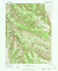
1952 Map of Segar Mountain
USGS Topo · Published 1972About this map
The Little Hills Game Experiment Station occupies the northwestern reaches of this 1952 topographic study, marking a period of active wildlife management in Rio Blanco County. The landscape is defined by the high elevations of Segar Mountain and a complex drainage system where Piceance Creek cuts through the western terrain. The map records early energy infrastructure with a Gas Well (Pump), illustrating the early development of local resources.
Find a feature on this map
21 named features on this map. Tap any name to fly to it.
Don’t see what you’re looking for? This feature index may not catch every label — zoom into the map to look around manually.
Map Details
Editions of this 1952 Segar Mountain Map
5 editions found

Other maps of this area

1906 · Grand Hogback
USGS Topo · 1:125,000

1907 · White River
USGS Topo · 1:125,000

1910 · Danforth Hills
USGS Topo · 1:125,000

1910 · Grand Hogback
USGS Topo · 1:125,000

1910 · White River
USGS Topo · 1:125,000

1912 · Meeker
USGS Topo · 1:62,500

1914 · Meeker
USGS Topo · 1:62,500

1952 · Jessup Gulch
USGS Topo · 1:24,000

1952 · Greasewood Gulch
USGS Topo · 1:24,000

1952 · No Name Ridge
USGS Topo · 1:24,000