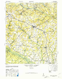
1944 Map of Seivern
USGS Topo · Published 1946About this map
The North Fork Edisto River and South Fork Edisto River define the rural character of this mid-1940s landscape, which spans parts of Aiken, Lexington, and Orangeburg Counties. Numerous millponds, such as Gunter Millpond and Rawls Millpond, dot the tributaries, reflecting an economy historically tied to water power and timber. Significant settlements like Wagener, Salley, and Springfield are established along the Southern railroad line, which served as a primary transportation corridor for this agricultural region.
Find a feature on this map
92 named features on this map. Tap any name to fly to it.
Don’t see what you’re looking for? This feature index may not catch every label — zoom into the map to look around manually.
Map Details
Editions of this 1944 Seivern Map
2 editions found

Other maps of this area

1919 · Bamberg
USGS Topo · 1:48,000

1920 · Bamberg
USGS Topo · 1:62,500

1920 · Aiken
USGS Topo · 1:48,000

1920 · Talatha
USGS Topo · 1:48,000

1921 · Aiken
USGS Topo · 1:62,500

1921 · Talatha
USGS Topo · 1:62,500

1923 · Williston
USGS Topo · 1:48,000

1927 · Williston
USGS Topo · 1:62,500

1943 · Aiken
USGS Topo · 1:62,500

1943 · Bamberg
USGS Topo · 1:62,500