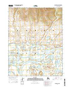
2015 Map of Selawik D-4 NW
USGS Topo · Published 2015About this map
The Kobuk River dominates this landscape in the Northwest Arctic, revealing a complex network of branching waterways and delta-like formations. The terrain is defined by the braided paths of the Nazuruk Channel, Melvin Channel, and Oksik Channel, which carve through the low-lying basin. To the northeast, the elevation rises toward the Kiana Hills, providing a sharp topographic contrast to the saturated river valley below. Near the confluence of Oksik Creek and its namesake channel lies Tenmile Post, a solitary named landmark that suggests the area's history of river travel and remote navigation. The map's detail provides a clear view of how water dictates the geography of this subarctic region, illustrating the seasonal and geological shifts of these major Alaskan watercourses.
Find a feature on this map
7 named features on this map. Tap any name to fly to it.
Don’t see what you’re looking for? This feature index may not catch every label — zoom into the map to look around manually.
Map Details
Editions of this 2015 Selawik D-4 NW Map
This is the sole edition of this map. No revisions or reprints were ever made.
Other maps of this area

1951 · Baird Mountains
USGS Topo · 1:250,000

1951 · Selawik
USGS Topo · 1:250,000

1955 · Selawik D-4
USGS Topo · 1:63,360

1955 · Selawik D-5
USGS Topo · 1:63,360
1955 · Baird Mountains A-5
USGS Topo · 1:63,360

1955 · Baird Mountains A-4
USGS Topo · 1:63,360

1956 · Baird Mountains
USGS Topo · 1:250,000

1957 · Selawik
USGS Topo · 1:250,000

1965 · Baird Mountains
USGS Topo · 1:250,000
2014 · Baird Mountains A-5 SE
USGS Topo · 1:25,000