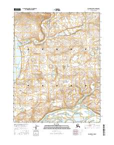
2016 Map of Selawik D-5 NW
USGS Topo · Published 2016About this map
Melvin Channel and Eavok Channel dominate the southern portion of this landscape, forming a complex network of waterways typical of the delta environments in the Northwest Arctic. These low-lying wetlands are punctuated by significant water bodies such as Ekichuk Lake and Potonie Lake near the western edge. The drainage pattern is further defined by Amadouk Creek, which meanders through the northern sections. This 2016 survey illustrates a largely uninhabited wilderness where the hydrography is the primary defining characteristic of the terrain, providing essential data for understanding the shifting channels and seasonal floodplains of the region's vast river systems.
Find a feature on this map
12 named features on this map. Tap any name to fly to it.
Don’t see what you’re looking for? This feature index may not catch every label — zoom into the map to look around manually.
Map Details
Editions of this 2016 Selawik D-5 NW Map
This is the sole edition of this map. No revisions or reprints were ever made.
Other maps of this area

1951 · Baird Mountains
USGS Topo · 1:250,000

1951 · Selawik
USGS Topo · 1:250,000

1951 · Selawik D-6
USGS Topo · 1:63,360

1952 · Selawik D-6
USGS Topo · 1:63,360

1955 · Selawik D-5
USGS Topo · 1:63,360
1955 · Baird Mountains A-5
USGS Topo · 1:63,360
1955 · Baird Mountains A-6
USGS Topo · 1:63,360

1956 · Baird Mountains
USGS Topo · 1:250,000

1957 · Selawik
USGS Topo · 1:250,000

1965 · Baird Mountains
USGS Topo · 1:250,000