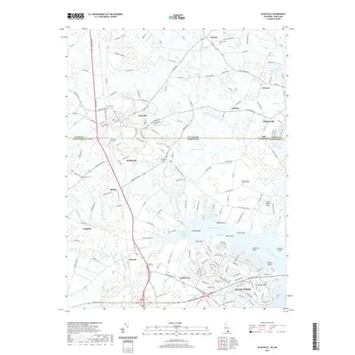
2019 Map of Selbyville
USGS Topo · Published 2019About this map
Ocean Pines and its contemporary residential development anchor the southern landscape where the Saint Martin River meets its many tidal prongs and creeks. This 2019 survey captures the interface between modern growth and the historic agricultural roots of the Delmarva Peninsula, straddling the Delaware Maryland state line. To the north, Selbyville remains a significant crossroads, while smaller settlements like Bishopville and Showell are surrounded by a dense network of cemeteries, including the Old Saint Martins Cem and Red Men Cem, reflecting deep-seated community lineages. The terrain is defined by a complex drainage system of ditches and branches, such as the Agricultural Ditch and Slab Bridge Prong, which have long shaped the region's farming and land use before reaching the coastal marshes near Jenkins Neck and Margots Island.
Find a feature on this map
63 named features on this map. Tap any name to fly to it.
Don’t see what you’re looking for? This feature index may not catch every label — zoom into the map to look around manually.
Map Details
Editions of this 2019 Selbyville Map
This is the sole edition of this map. No revisions or reprints were ever made.
Other maps of this area

1901 · Ocean City
USGS Topo · 1:62,500

1902 · Pittsville
USGS Topo · 1:62,500

1917 · Millsboro
USGS Topo · 1:62,500

1918 · Rehoboth
USGS Topo · 1:62,500

1938 · Millsboro
USGS Topo · 1:62,500

1938 · Rehoboth
USGS Topo · 1:62,500

1942 · Ocean City
USGS Topo · 1:62,500

1942 · Ninepin
USGS Topo · 1:24,000

1942 · Ocean City
USGS Topo · 1:24,000

1942 · Whaleysville
USGS Topo · 1:24,000