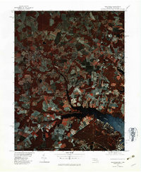
1980 Map of Selbyville
USGS Topo · Published 1982About this map
Agricultural fields and dense woodlands dominate this 1980 infrared color orthophotoquad, which captures the coastal plain landscape along the Delaware and Maryland border. The town of Selbyville serves as the primary hub in the northwest, surrounded by a mosaic of farm plots and timber tracks. To the east and south, the drainage patterns of the St Martin River and Birch Branch dictate the local geography, leading toward the Maryland settlements of Bishopville and Showell.
Find a feature on this map
9 named features on this map. Tap any name to fly to it.
Don’t see what you’re looking for? This feature index may not catch every label — zoom into the map to look around manually.
Map Details
Editions of this 1980 Selbyville Map
This is the sole edition of this map. No revisions or reprints were ever made.
Other maps of this area

1901 · Ocean City
USGS Topo · 1:62,500

1902 · Pittsville
USGS Topo · 1:62,500

1917 · Millsboro
USGS Topo · 1:62,500

1918 · Rehoboth
USGS Topo · 1:62,500

1938 · Millsboro
USGS Topo · 1:62,500

1938 · Rehoboth
USGS Topo · 1:62,500

1942 · Ocean City
USGS Topo · 1:62,500

1942 · Ninepin
USGS Topo · 1:24,000

1942 · Ocean City
USGS Topo · 1:24,000

1942 · Whaleysville
USGS Topo · 1:24,000