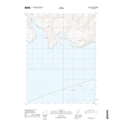
2018 Map of Seldovia A-4 NE
USGS Topo · Published 2018About this map
Kenai Peninsula coastline dominates this 2018 survey, where the terrestrial landscape meets the Pacific Ocean along a complex of remote inlets. The shore is defined by the significant indentations of Qikutulig Bay and Touglaalek Bay, separated by high-elevation ridges that rise steeply from the water. Farther out to sea, Gore Rock serves as a prominent maritime landmark south of the peninsula's jagged southern edge. This map provides a detailed look at the interface between the high relief of the Alaskan coastal mountains and the sea, showing a landscape shaped by natural forces without established roads or settlements. The land is organized by the Public Land Survey System, with township and range lines like t11s r12w and t11s r11w overlaying the wilderness.
Find a feature on this map
8 named features on this map. Tap any name to fly to it.
Don’t see what you’re looking for? This feature index may not catch every label — zoom into the map to look around manually.
Map Details
Editions of this 2018 Seldovia A-4 NE Map
This is the sole edition of this map. No revisions or reprints were ever made.
Other maps of this area

1951 · Seldovia
USGS Topo · 1:250,000

1951 · Seldovia A-3
USGS Topo · 1:63,360

1951 · Seldovia B-4
USGS Topo · 1:63,360

1951 · Seldovia B-3
USGS Topo · 1:63,360

1951 · Seldovia A-4
USGS Topo · 1:63,360

1952 · Seldovia A-3
USGS Topo · 1:63,360

1952 · Seldovia B-3
USGS Topo · 1:63,360

1953 · Seldovia B-4
USGS Topo · 1:63,360
1953 · Seldovia A-4
USGS Topo · 1:63,360

1963 · Seldovia
USGS Topo · 1:250,000