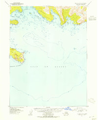
1953 Map of Seldovia A-4
USGS Topo · Published 1955About this map
Gulf of Alaska waters dominate this mid-century topographic record, which focuses on the southern maritime edge of the Kenai Peninsula. The map provides a detailed look at the rugged coastline where Rocky Bay and Windy Bay indent the mainland, separated by steep, high-elevation terrain. This survey, compiled from 1951 aerial photography and 1953 multiplex methods, highlights the complex hydrography of the region, including the navigational hazard of Gore Rock and the surrounding bathymetric contours. To the southwest, East Chugach Island stands as a prominent landmark within the Chugach Islands chain, its peaks rising sharply from the sea. The cartography emphasizes the interface between the open ocean and the dramatic coastal landforms, capturing the area before modern development or environmental shifts altered the shoreline of this remote Alaskan reach.
Find a feature on this map
12 named features on this map. Tap any name to fly to it.
Don’t see what you’re looking for? This feature index may not catch every label — zoom into the map to look around manually.
Map Details
Editions of this 1953 Seldovia A-4 Map
2 editions found
Other maps of this area

1951 · Seldovia
USGS Topo · 1:250,000

1951 · Seldovia B-5
USGS Topo · 1:63,360

1951 · Seldovia A-3
USGS Topo · 1:63,360

1951 · Seldovia B-4
USGS Topo · 1:63,360

1951 · Seldovia B-3
USGS Topo · 1:63,360

1951 · Seldovia A-4
USGS Topo · 1:63,360

1952 · Afognak
USGS Topo · 1:250,000

1952 · Seldovia A-3
USGS Topo · 1:63,360

1952 · Seldovia B-3
USGS Topo · 1:63,360

1953 · Seldovia B-4
USGS Topo · 1:63,360