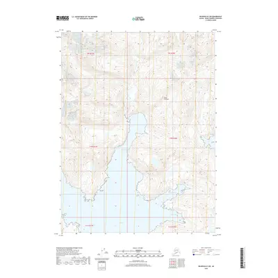
2018 Map of Seldovia B-3 SW
USGS Topo · Published 2018About this map
The southern reach of the Kenai Peninsula is defined by a complex maritime coastline where deep glacial inlets meet the Gulf of Alaska. This 2018 survey documents the intricate shoreline and steep bathymetry of the region, anchored by the wide mouth of Port Dick. The topographic data highlights the extreme elevation changes between the coastal waters and the interior mountain ridges, illustrating how the terrain naturally funnelled historical maritime access through sheltered anchorages. Significant nautical landmarks include Taylor Bay, which penetrates deep into the peninsula, and the smaller inlets of Sunday Harbor and Takoma Cove. These features represent critical points of refuge and navigation for the region's fishing and maritime industries, remaining largely undeveloped and preserved in their natural state.
Find a feature on this map
11 named features on this map. Tap any name to fly to it.
Don’t see what you’re looking for? This feature index may not catch every label — zoom into the map to look around manually.
Map Details
Editions of this 2018 Seldovia B-3 SW Map
This is the sole edition of this map. No revisions or reprints were ever made.
Other maps of this area

1951 · Seldovia
USGS Topo · 1:250,000

1951 · Seldovia A-3
USGS Topo · 1:63,360

1951 · Seldovia B-4
USGS Topo · 1:63,360

1951 · Seldovia B-3
USGS Topo · 1:63,360

1951 · Seldovia A-4
USGS Topo · 1:63,360

1952 · Seldovia A-3
USGS Topo · 1:63,360

1952 · Seldovia B-3
USGS Topo · 1:63,360

1953 · Seldovia B-4
USGS Topo · 1:63,360
1953 · Seldovia A-4
USGS Topo · 1:63,360

1963 · Seldovia
USGS Topo · 1:250,000