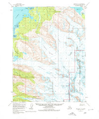
1951 Map of Seldovia C-3
USGS Topo · Published 1980About this map
Kachemak Bay dominates the northwestern corner of this mid-century survey, where the saltwater interface of Bear Cove and Aurora Lagoon meets the massive ice sheets of the Kenai Peninsula. The map documents a landscape defined by moving ice and tidal reaches, showing the vast extent of the Portlock Glacier and Dixon Glacier as they flowed toward the coast prior to modern recession. Human presence is sparse, limited to a few scattered Cabins near the shoreline of Kachemak Bay State Park. Notable geographical features such as the long reach of Aurora Spit and the high elevation of Iceworm Peak highlight the dramatic relief between the sea and the ice-capped interior. The drainage of Battle Creek into Bradley Lake and the various glacial moraines provide a detailed look at the hydrology of this protected wilderness area during the early 1950s.
Find a feature on this map
26 named features on this map. Tap any name to fly to it.
Don’t see what you’re looking for? This feature index may not catch every label — zoom into the map to look around manually.
Map Details
Editions of this 1951 Seldovia C-3 Map
4 editions found

Other maps of this area

1948 · Seldovia C-4
USGS Topo · 1:63,360

1949 · Seldovia C-4
USGS Topo · 1:62,500

1949 · Seldovia D-4
USGS Topo · 1:63,360

1950 · Seldovia D-2
USGS Topo · 1:63,360

1951 · Seldovia D-4
USGS Topo · 1:63,360

1951 · Seldovia
USGS Topo · 1:250,000

1951 · Seldovia D-3
USGS Topo · 1:63,360

1951 · Seldovia B-4
USGS Topo · 1:63,360

1951 · Seldovia B-2
USGS Topo · 1:63,360

1951 · Seldovia B-3
USGS Topo · 1:63,360