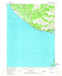
1961 Map of Seldovia C-5
USGS Topo · Published 1967About this map
The settlement of Homer sits at the base of several prominent coastal elevations including Diamond Ridge and Skyline Ridge, where the Kenai Peninsula meets the waters of Kachemak Bay. This 1960s-era documentation shows the town's logistical foundations, featuring the Sterling Highway as the primary artery connecting the coast to the interior. Notable infrastructure of the period includes the Seaplane Base on the shores of Beluga Lake and various communications facilities like the FAA Range Sta and Radio Towers positioned along the higher terrain.
Find a feature on this map
39 named features on this map. Tap any name to fly to it.
Don’t see what you’re looking for? This feature index may not catch every label — zoom into the map to look around manually.
Map Details
Editions of this 1961 Seldovia C-5 Map
4 editions found

Other maps of this area

1946 · Seldovia C-5
USGS Topo · 1:63,360

1946 · Seldovia D-5
USGS Topo · 1:63,360

1948 · Seldovia C-4
USGS Topo · 1:63,360

1949 · Seldovia C-4
USGS Topo · 1:62,500

1949 · Seldovia D-4
USGS Topo · 1:63,360

1951 · Seldovia C-5
USGS Topo · 1:63,360

1951 · Seldovia D-5
USGS Topo · 1:63,360

1951 · Seldovia D-4
USGS Topo · 1:63,360

1951 · Seldovia
USGS Topo · 1:250,000

1951 · Seldovia B-5
USGS Topo · 1:63,360