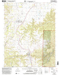
1999 Map of Seligman
USGS Topo · Published 2002About this map
Washburn and Seligman anchor this rural landscape in the southwest corner of Missouri, just north of the border between Missouri and Arkansas. The area is defined by a series of named hollows and ridges, including Washburn Hollow, Blockade Hollow, and Sparkman Hollow, which feed into local waterways like Flat Creek. Genealogists will find several burial grounds across the township, such as Riley Cemetery and Washburn Prairie Cemetery, while local community life is marked by country churches like Rock Springs Church and Salem Church. To the east, the terrain shifts into the protected boundaries of the Mark Twain National Forest, where Long Ridge and Butler Creek dominate the interior. The map also identifies local landmarks like McCann Cave and the Reed Mountain area, providing a look at the intersection of agriculture and forest land at the close of the twentieth century.
Find a feature on this map
31 named features on this map. Tap any name to fly to it.
Don’t see what you’re looking for? This feature index may not catch every label — zoom into the map to look around manually.
Map Details
Editions of this 1999 Seligman Map
This is the sole edition of this map. No revisions or reprints were ever made.
Other maps of this area

1899 · Fayetteville
USGS Topo · 1:125,000

1900 · Eureka Springs
USGS Topo · 1:125,000

1901 · Eureka Springs
USGS Topo · 1:125,000

1901 · Fayetteville
USGS Topo · 1:125,000

1904 · Fayetteville
USGS Topo · 1:125,000

1937 · Cassville
USGS Topo · 1:48,000

1941 · Rocky Comfort
USGS Topo · 1:62,500

1943 · Rocky Comfort
USGS Topo · 1:62,500

1944 · Cassville
USGS Topo · 1:62,500

1945 · Harrison
USGS Topo · 1:250,000