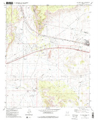
1981 Map of Seligman West
USGS Topo · Published 1985About this map
The Atchison Topeka and Santa Fe railroad corridor anchors this high-desert landscape as it traverses the northern Arizona plateau. The settlement of Seligman serves as the focal point, positioned where the terrain transitions from the Aubrey Cliffs and Aubrey Valley toward the drainage of Big Chino Wash. Water management in this arid environment is clearly documented through an extensive network of artificial features, including the Seligman Dam, Canyon Mouth Dam, and Telephone Dam, alongside livestock-related infrastructure such as Shorty Tank and the Buck Rogers Well. The map captures the industrial and logistical character of the era, noting numerous quarry and borrow pit sites, a Radio Facility, and a Landing Strip, illustrating the region's role as a vital transportation and infrastructure hub between the Juniper Mountains and Red Mesa.
Find a feature on this map
26 named features on this map. Tap any name to fly to it.
Don’t see what you’re looking for? This feature index may not catch every label — zoom into the map to look around manually.
Map Details
Editions of this 1981 Seligman West Map
3 editions found
Other maps of this area

1886 · Diamond Creek
USGS Topo · 1:250,000

1886 · Chino
USGS Topo · 1:250,000

1891 · Chino
USGS Topo · 1:250,000

1892 · Diamond Creek
USGS Topo · 1:250,000

1947 · Turkey Canyon
USGS Topo · 1:62,500

1948 · Williams
USGS Topo · 1:250,000

1950 · Turkey Canyon
USGS Topo · 1:62,500

1954 · Williams
USGS Topo · 1:250,000

1956 · Williams
USGS Topo · 1:250,000

1960 · Williams
USGS Topo · 1:250,000