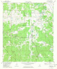
1981 Map of Sellers
USGS Topo · Published 1981About this map
The Seaboard Coast Line railroad carves a path through the rolling rural landscape of the Montgomery and Crenshaw County border, connecting small agricultural centers during the early 1980s. This survey documents the persistent settlement patterns of central Alabama, where communities like Fleta, Sellers, and Ada are anchored by local landmarks such as Friendship Ch and Mose Chapel. The terrain is defined by the winding course of Pintlalla Creek and numerous small water bodies including Lake Tal-lale and Leisure Lake, which support the region's long-standing connection to the land.
Find a feature on this map
46 named features on this map. Tap any name to fly to it.
Don’t see what you’re looking for? This feature index may not catch every label — zoom into the map to look around manually.
Map Details
Editions of this 1981 Sellers Map
2 editions found
Other maps of this area

1953 · Montgomery
USGS Topo · 1:250,000

1953 · Andalusia
USGS Topo · 1:250,000

1956 · Montgomery
USGS Topo · 1:250,000

1957 · Montgomery
USGS Topo · 1:250,000

1957 · Andalusia
USGS Topo · 1:250,000

1957 · Letohatchee
USGS Topo · 1:62,500

1968 · Grady
USGS Topo · 1:24,000

1971 · Danielsville
USGS Topo · 1:24,000

1971 · Davis Crossroads
USGS Topo · 1:24,000
1971 · Ramer
USGS Topo · 1:24,000