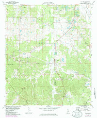
1981 Map of Sellers
USGS Topo · Published 1986About this map
Pintlalla Creek winds through the heart of this landscape along the border of Montgomery and Crenshaw counties, anchoring a network of small agricultural settlements and country churches. The rail-oriented economy of the early 1980s is centered on the Seaboard Coast Line corridor, which connects the community of Ada with the northern reaches of the quadrangle. Local life is concentrated around crossroads and family landmarks such as Fleta, Glyn Crossroads, and the high ground of Mt Carmel.
Find a feature on this map
41 named features on this map. Tap any name to fly to it.
Don’t see what you’re looking for? This feature index may not catch every label — zoom into the map to look around manually.
Map Details
Editions of this 1981 Sellers Map
2 editions found
Other maps of this area

1953 · Montgomery
USGS Topo · 1:250,000

1953 · Andalusia
USGS Topo · 1:250,000

1956 · Montgomery
USGS Topo · 1:250,000

1957 · Montgomery
USGS Topo · 1:250,000

1957 · Andalusia
USGS Topo · 1:250,000

1957 · Letohatchee
USGS Topo · 1:62,500

1968 · Grady
USGS Topo · 1:24,000

1971 · Danielsville
USGS Topo · 1:24,000

1971 · Davis Crossroads
USGS Topo · 1:24,000
1971 · Ramer
USGS Topo · 1:24,000