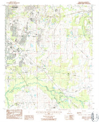
1987 Map of Barachias
USGS Topo · Published 1987About this map
The southern outskirts of Montgomery and the rural community of Barachias characterize this late-twentieth-century landscape. The map illustrates a period of significant suburban expansion and institutional development, evidenced by the cluster of schools and churches like the Montgomery Catholic High Sch, Central Alabama Academy, and Harvest Time Ch. The transition from city to countryside is marked by the Corporate Limits and a notable density of family-named cemeteries, including the Taylor Cem, Freeman Cem, and Pinkston Cem, which provide valuable clues for local family history.
Find a feature on this map
47 named features on this map. Tap any name to fly to it.
Don’t see what you’re looking for? This feature index may not catch every label — zoom into the map to look around manually.
Map Details
Editions of this 1987 Barachias Map
2 editions found
Other maps of this area

1927 · Montgomery
USGS Topo · 1:48,000

1930 · Montgomery
USGS Topo · 1:62,500

1953 · Montgomery
USGS Topo · 1:250,000

1956 · Montgomery
USGS Topo · 1:250,000

1957 · Montgomery
USGS Topo · 1:250,000

1957 · Letohatchee
USGS Topo · 1:62,500

1958 · Montgomery
USGS Topo · 1:62,500

1958 · Montgomery North
USGS Topo · 1:24,000

1958 · Montgomery South
USGS Topo · 1:24,000

1958 · Mount Meigs
USGS Topo · 1:62,500