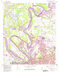
1958 Map of Montgomery North
USGS Topo · Published 1982About this map
The Alabama River winds through the heart of this landscape, its serpentine path defining the boundaries between Montgomery and Elmore counties. To the south, the city of Montgomery shows its mid-century urban density, anchored by the State Capitol and City Hall. This period of growth is reflected in the extensive rail networks of the Western Railway of Alabama and the Seaboard Coast Line that converge near industrial zones and neighborhoods like Chisholm and Highland Gardens.
Find a feature on this map
54 named features on this map. Tap any name to fly to it.
Don’t see what you’re looking for? This feature index may not catch every label — zoom into the map to look around manually.
Map Details
Editions of this 1958 Montgomery North Map
4 editions found
Other maps of this area

1901 · Wetumpka
USGS Topo · 1:125,000

1901 · Wetumpka
USGS Topo · 1:62,500

1903 · Wetumpka
USGS Topo · 1:125,000

1927 · Montgomery
USGS Topo · 1:48,000

1930 · Montgomery
USGS Topo · 1:62,500

1953 · Montgomery
USGS Topo · 1:250,000

1956 · Montgomery
USGS Topo · 1:250,000

1957 · Montgomery
USGS Topo · 1:250,000

1958 · Montgomery
USGS Topo · 1:62,500

1958 · Montgomery North
USGS Topo · 1:24,000