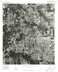
1975 Map of Montgomery SW
USGS Topo · Published 1977About this map
The Alabama River winds through the northwestern corner of this 1975 orthophotoquad, defining a landscape of agricultural utility and transition. As an aerial-derived image rather than a traditional line map, it provides a high-resolution view of the patchwork of fields, woodlots, and emerging infrastructure on the outskirts of the state capital. The visible texture of the land reveals a complex network of farm roads and drainage patterns surrounding the river's serpentine path, capturing a specific moment of mid-century land use before subsequent decades of suburban expansion and development reshaped this Alabama corridor.
Find a feature on this map
1 named feature on this map. Tap any name to fly to it.
Don’t see what you’re looking for? This feature index may not catch every label — zoom into the map to look around manually.
Map Details
Editions of this 1975 Montgomery SW Map
This is the sole edition of this map. No revisions or reprints were ever made.
Other maps of this area

1927 · Montgomery
USGS Topo · 1:48,000

1930 · Montgomery
USGS Topo · 1:62,500

1953 · Montgomery
USGS Topo · 1:250,000

1956 · Montgomery
USGS Topo · 1:250,000

1957 · Montgomery
USGS Topo · 1:250,000

1957 · Letohatchee
USGS Topo · 1:62,500

1957 · Autaugaville
USGS Topo · 1:62,500

1958 · Montgomery
USGS Topo · 1:62,500

1958 · Montgomery North
USGS Topo · 1:24,000

1958 · Montgomery South
USGS Topo · 1:24,000