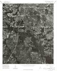
1975 Map of Montgomery South
USGS Topo · Published 1977About this map
Montgomery expands southward in this mid-1970s orthophotoquad, where dense urban development meets the winding path of Catoma Creek. The imagery captures a distinct transition from the grid-like residential and industrial sprawl of the city to the more open, pastoral lands of southern Montgomery County. Along the western edge, the settlement of Hope Hull sits positioned near major transit corridors, reflecting the area's growth patterns at the time. To the east, the neighborhood of Lynndale represents the suburban frontier of the era. This specialized survey provides a clear visual record of land use before further modernization altered the rural-urban fringe, making it a valuable resource for tracing property boundaries and the evolution of the Alabama capital's southern outskirts.
Find a feature on this map
4 named features on this map. Tap any name to fly to it.
Don’t see what you’re looking for? This feature index may not catch every label — zoom into the map to look around manually.
Map Details
Editions of this 1975 Montgomery South Map
This is the sole edition of this map. No revisions or reprints were ever made.
Other maps of this area

1927 · Montgomery
USGS Topo · 1:48,000

1930 · Montgomery
USGS Topo · 1:62,500

1953 · Montgomery
USGS Topo · 1:250,000

1956 · Montgomery
USGS Topo · 1:250,000

1957 · Montgomery
USGS Topo · 1:250,000

1957 · Letohatchee
USGS Topo · 1:62,500

1958 · Montgomery
USGS Topo · 1:62,500

1958 · Montgomery North
USGS Topo · 1:24,000

1958 · Montgomery South
USGS Topo · 1:24,000

1958 · Mount Meigs
USGS Topo · 1:62,500
Featured Places
- Montgomery, AL
- Perry Hills, Montgomery
- Cleveland Meadows, Montgomery
- Windwood, Montgomery
- Mayfair, Montgomery